Archivo:HeimSachsen.png

Tamaño de esta previsualización: 551 × 599 píxeles. Otras resoluciones: 221 × 240 píxeles · 441 × 480 píxeles · 881 × 958 píxeles.
Ver la imagen en su resolución original (881 × 958 píxeles; tamaño de archivo: 346 kB; tipo MIME: image/png)

Resumen
| Descripción |
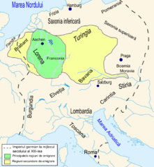
Română: Regiunile de provenienţă ale coloniştilor saşi în Transilvania în secolul al XIII-lea. |
| Fecha | |
| Fuente | Th.Nagler - Asezarea saşilor în Transilvania - Bucureşti, Editura Kriterion, 1992, planşa X. |
| Autor | Asybaris |

|
Esta imagen debería volverse a crear como imágenes vectoriales SVG. Esto proporciona muchas ventajas, véase Commons:Media for cleanup (en inglés) para más información. Si ya hay una versión SVG de esta imagen disponible, por favor súbala a Commons. Tras subirla, reemplace esta plantilla con la plantilla
{{vector version available|nuevo nombre de imagen.svg}} en esta imagen. |
Licencia
| Yo, el titular de los derechos de autor de esta obra, lo libero al dominio público. Esto aplica en todo el mundo. En algunos países esto puede no ser legalmente factible; si ello ocurriese: Concedo a cualquier persona el derecho de usar este trabajo para cualquier propósito, sin ningún tipo de condición al menos que éstas sean requeridas por la ley. |
Historial del archivo
Haz clic sobre una fecha y hora para ver el archivo tal como apareció en ese momento.
| Fecha y hora | Miniatura | Dimensiones | Usuario | Comentario | |
|---|---|---|---|---|---|
| actual | 18:02 13 feb 2009 | | 881 × 958 (346 kB) | Asybaris01 | corectii |
| 16:41 13 feb 2009 |  | 881 × 958 (339 kB) | Asybaris01 | {{Information |Description={{ro|1=Regiunile de provenienţă ale coloniştilor saşi în Transilvania în secolul al XIII-lea.}} |Source=Th.Nagler - Asezarea saşilor în Transilvania - Bucureşti, Editura Kriterion, 1992, planşa X. |Author=[[:ro:Utiliz |
Usos del archivo
La siguiente página usa este archivo:
Uso global del archivo
Las wikis siguientes utilizan este archivo:
- Uso en el.wikipedia.org
- Uso en en.wikipedia.org
- Uso en ro.wikipedia.org
- Uso en sl.wikipedia.org