Archivo:Homann Planiglobii Terrestris Cumutroq Hemisphaerio Caelesti Generalis Exhibitio 1707 UTA.jpg

Tamaño de esta previsualización: 692 × 599 píxeles. Otras resoluciones: 277 × 240 píxeles · 554 × 480 píxeles · 887 × 768 píxeles · 1182 × 1024 píxeles · 2364 × 2048 píxeles · 3103 × 2688 píxeles.
Ver la imagen en su resolución original (3103 × 2688 píxeles; tamaño de archivo: 2,35 MB; tipo MIME: image/jpeg)
Resumen
| Título |
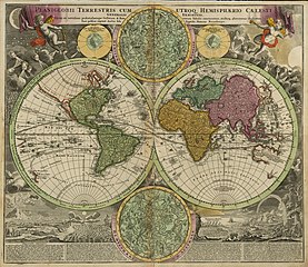
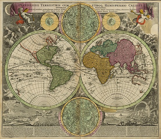
Latina: Planiglobii Terrestris cum Utroq Hemisphaerio Caelesti Generalis Exhibitio... |
||||||||||||||||||||||||||
| Descripción |
English: This double-hemisphere world map features insets of the celestial northern hemisphere and the celestial southern hemisphere, both of which show the mythological figures and objects of the constellations. Windheads and illustrations of a volcanic eruption, earthquake, tides, water-spouts, and a rainbow decorate the four corners of the composition. The map shows California as insular and traces the sailing routes of the explorers Magellan, Olivier van Noort, William Dampier, Abel Tasman, and Juan Gaetano.
Nuremberg cartographer and map publisher Homann and his family later produced a number of celestial and selenographical (lunar) charts in conjunction with the Nuremberg astronomer and mathematician Johann Gabriel Doppelmayr (1677-1750). Many of these charts were featured in Doppelmayr's Atlas coelestis, which Homann's Heirs published in 1742. |
||||||||||||||||||||||||||
| Fecha | |||||||||||||||||||||||||||
| Fuente | UTA Libraries Cartographic Connections: mapa / texto | ||||||||||||||||||||||||||
| Creador |
|
||||||||||||||||||||||||||
| Adquisición |
English: UTA Libraries Special Collections, Gift of Virginia Garrett |
||||||||||||||||||||||||||
| Georeferencing | If inappropriate please set warp_status = skip to hide. | ||||||||||||||||||||||||||
| Bibliographic data | |||||||||||||||||||||||||||
| Publicación |
Atlas Novus Terrarum Orbis Imperia |
||||||||||||||||||||||||||
| Autor |
|
||||||||||||||||||||||||||
| Lugar de publicación | Núremberg | ||||||||||||||||||||||||||
| Editorial |
|
||||||||||||||||||||||||||
| Archival data | |||||||||||||||||||||||||||
| Colección |
|
||||||||||||||||||||||||||
| Dimensiones | altura: 49 cm; ancho: 57,2 cm | ||||||||||||||||||||||||||
| Técnica | grabado coloreado | ||||||||||||||||||||||||||
| artwork-references |
Moreland y Bannister. "Homann Heirs". Error: journal= not stated. Warner, Deborah J. (1979) The Sky Explored: Celestial Cartography 1500-1800, Nueva York: Alan R. Liss, Inc., p. 120 |
||||||||||||||||||||||||||
.jpg)
Licencia

|
This file was provided to Wikimedia Commons by the University of Texas at Arlington Libraries as part of a cooperation project. The University of Texas at Arlington Libraries is part of the University of Texas at Arlington, a public research university located in Arlington, Texas.
|
|
Este material está en dominio público en los demás países donde el derecho de autor se extiende por 100 años (o menos) tras la muerte del autor. Esta obra está en el dominio público en los Estados Unidos porque fue publicada (o registrada con la Oficina del Derecho de Autor de los E.E. U.U.) antes del 1 de enero de 1929. | |
| Esta obra ha sido identificada como libre de las restricciones conocidas en virtud del derecho de autor, incluyendo todos los derechos conexos. | |
Historial del archivo
Haz clic sobre una fecha y hora para ver el archivo tal como apareció en ese momento.
| Fecha y hora | Miniatura | Dimensiones | Usuario | Comentario | |
|---|---|---|---|---|---|
| actual | 21:22 10 feb 2022 | | 3103 × 2688 (2,35 MB) | Michael Barera | == {{int:filedesc}} == {{Map |title = {{la|'''''laniglobii Terrestris cum Utroq Hemisphaerio Caelesti Generalis Exhibitio...'''''}} |description = {{en|This double-hemisphere world map features insets of the celestial northern hemisphere and the celestial southern hemisphere, both of which show the mythological figures and objects of the constellations. Windheads and illustrations of a volcanic eruption, earthquake, tides, water-spouts, and a rainbow decorate the four corn... |
Usos del archivo
La siguiente página usa este archivo:
Uso global del archivo
Las wikis siguientes utilizan este archivo:
- Uso en de.wikipedia.org
- Uso en en.wikipedia.org
- Uso en fa.wikipedia.org
- Uso en fr.wikipedia.org
- Uso en id.wikipedia.org
- Uso en la.wikipedia.org
- Uso en nl.wikipedia.org
- Uso en pt.wikipedia.org
- Uso en ro.wikipedia.org
- Uso en ru.wikipedia.org
- Uso en sr.wikipedia.org
- Uso en sv.wikipedia.org
- Uso en uk.wikipedia.org