Archivo:Iceland Mid-Atlantic Ridge Fig16.gif
Iceland_Mid-Atlantic_Ridge_Fig16.gif (376 × 390 píxeles; tamaño de archivo: 9 kB; tipo MIME: image/gif)
Historial del archivo
Haz clic sobre una fecha y hora para ver el archivo tal como apareció en ese momento.
| Fecha y hora | Miniatura | Dimensiones | Usuario | Comentario | |
|---|---|---|---|---|---|
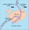
| actual | 23:02 9 mar 2005 |  | 376 × 390 (9 kB) | Svart~commonswiki | Map showing the Mid-Atlantic Ridge splitting Iceland and separating the North American and Eurasian Plates. The map also shows Reykjavik, the capital of Iceland, the Thingvellir area, and the locations of some of Iceland's active volcanoes (red triangles) |
Usos del archivo
Las siguientes páginas usan este archivo:
Uso global del archivo
Las wikis siguientes utilizan este archivo:
- Uso en ar.wikipedia.org
- Uso en ast.wikipedia.org
- Uso en azb.wikipedia.org
- Uso en bg.wikipedia.org
- Uso en bn.wikipedia.org
- Uso en bn.wikivoyage.org
- Uso en cs.wikipedia.org
- Uso en de.wikipedia.org
- Uso en de.wikivoyage.org
- Uso en dz.wikipedia.org
- Uso en en.wikipedia.org
- Uso en eo.wikipedia.org
- Uso en fa.wikipedia.org
- Uso en fiu-vro.wikipedia.org
- Uso en fi.wikipedia.org
- Uso en hr.wikipedia.org
- Uso en hu.wikipedia.org
- Uso en is.wikipedia.org
- Uso en is.wikibooks.org
- Uso en it.wikipedia.org
- Uso en ja.wikipedia.org
- Uso en ms.wikipedia.org
- Uso en nds.wikipedia.org
- Uso en nn.wikipedia.org
- Uso en no.wikipedia.org
- Uso en pl.wikipedia.org
- Uso en pt.wikipedia.org
- Uso en rm.wikipedia.org
- Uso en ro.wikipedia.org
- Uso en ru.wikipedia.org
Ver más uso global de este archivo.


