Archivo:Karlatornet från Surbrunnsgatan 18 februari 2023.jpg

Ver la imagen en su resolución original (3310 × 4056 píxeles; tamaño de archivo: 8,98 MB; tipo MIME: image/jpeg)
Resumen
| Descripción |
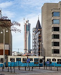
English: Skyscraper Karlatornet in Gothenburg, Sweden, under construction. The picture was taken from Surbrunnsgatan across the river Göta Älv.
Svenska: Skyskrapan Karlatornet i Göteborg under konstruktion. Bilden är tagen från Surbrunnsgatan på andra sidan Göta älv. |
|||
| Fecha | 12:56:32.16 | |||
| Fuente | Trabajo propio | |||
| Autor |
|

| Posición de la cámara | | Ubicación de esta y otras imágenes en: OpenStreetMap |
|---|
Licencia
| Este archivo está disponible bajo la licencia Creative Commons Dedicación de Dominio Público CC0 1.0 Universal. | |
| La persona que ha asociado una obra a este documento lo dedica al dominio público mediante la cesión mundial de sus derechos bajo la ley de derechos de autor y todos los derechos legales adyacentes propios de dicha, en el ámbito permitido por ley. Puedes copiar, modificar, distribuir y reproducir el trabajo, incluso con objetivos comerciales, sin pedir aprobación del autor.
|
| Annotations | This image is annotated: View the annotations at Commons |
Historial del archivo
Haz clic sobre una fecha y hora para ver el archivo tal como apareció en ese momento.
| Fecha y hora | Miniatura | Dimensiones | Usuario | Comentario | |
|---|---|---|---|---|---|
| actual | 07:23 7 mar 2023 | | 3310 × 4056 (8,98 MB) | Dcastor | Uploaded with LrMediaWiki 1.8.0, LR 12.2 Win |
Usos del archivo
La siguiente página usa este archivo:
Uso global del archivo
Las wikis siguientes utilizan este archivo:
- Uso en sv.wikipedia.org