Archivo:Karte Römische Städte in Nordafrika.svg

Ver la imagen en su resolución original ((Imagen SVG, nominalmente 1011 × 336 pixels, tamaño de archivo: 821 kB))
Resumen
| Descripción |
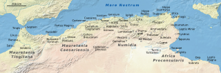
Deutsch: Karte der römischen Städte in Nordafrika |
| Fecha | |
| Fuente |
|
| Autor | NordNordWest |

|
Este mapa se ha hecho o mejorado en el Kartenwerkstatt (taller cartográfico) alemán. También puede proponer mapas para mejorar.
|
Licencia
Usage of this file with:

explanatory notes: Legally binding is only the full legalcode. For a free usage I recommend to respect the following licence conditions:
1. Provide my name as given above: NordNordWest,
2. a copy of, or the URI for, the applicable license: https://creativecommons.org/licenses/by-sa/3.0/de/legalcode,
3. the title of the work,
4. in the case of an adaptation, a credit identifying the use of the work in the adaptation.
This license and the rights granted hereunder will terminate automatically upon any breach by you of the terms of this license. Any of the above conditions can be waived if you get permission from the copyright holder. If you have questions or wish differing conditions, please contact me through nnwest or my discussion page ![]() t-online.de
t-online.de
- Eres libre:
- de compartir – de copiar, distribuir y transmitir el trabajo
- de remezclar – de adaptar el trabajo
- Bajo las siguientes condiciones:
- atribución – Debes otorgar el crédito correspondiente, proporcionar un enlace a la licencia e indicar si realizaste algún cambio. Puedes hacerlo de cualquier manera razonable pero no de manera que sugiera que el licenciante te respalda a ti o al uso que hagas del trabajo.
- compartir igual – En caso de mezclar, transformar o modificar este trabajo, deberás distribuir el trabajo resultante bajo la misma licencia o una compatible como el original.

Historial del archivo
Haz clic sobre una fecha y hora para ver el archivo tal como apareció en ese momento.
| Fecha y hora | Miniatura | Dimensiones | Usuario | Comentario | |
|---|---|---|---|---|---|
| actual | 17:43 16 may 2022 | 1011 × 336 (821 kB) | NordNordWest | == {{int:filedesc}} == {{Information |description= {{de|1=Karte der römischen Städte in Nordafrika}} |source= * Putzger Historischer Atlas, Cornelsen Verlag, Berlin, 2001 * [http://www.shadedrelief.com/natural/pages/download.html Natural Earth, Tom Patterson, US National Park Service] |date={{Date|2022|05|16}} |author={{U|NordNordWest}} |permission= |other_versions= }} {{Kartenwerkstatt}} == {{int:license-header}} == {{User:NordNordWest/LicenceMap}} Category:Maps of Roman provinces [[Ca... |
Usos del archivo
Las siguientes páginas usan este archivo:
Uso global del archivo
Las wikis siguientes utilizan este archivo:
- Uso en ar.wikipedia.org
- Uso en ast.wikipedia.org
- Uso en de.wikipedia.org
- Uso en en.wikipedia.org
- Uso en et.wikipedia.org
- Uso en fr.wikipedia.org
- Site archéologique de Volubilis
- Tlemcen
- Timgad
- Hippone
- Biskra
- Tébessa
- Mostaganem
- Afrique romaine
- Ténès
- Dougga
- Bethioua
- Djemila
- Lambèse
- Legio III Augusta
- Sabratha
- Liste des noms latins des villes d'Afrique
- Liste des ports antiques
- Annaba
- Maroc
- Tobna
- Auzia
- Altava
- Systèmes défensifs de l'Afrique romaine
Ver más uso global de este archivo.