Archivo:London1300-marking the spot of the future Marshalsea.png

London1300-marking_the_spot_of_the_future_Marshalsea.png (700 × 536 píxeles; tamaño de archivo: 693 kB; tipo MIME: image/png)
Resumen
| Descripción |
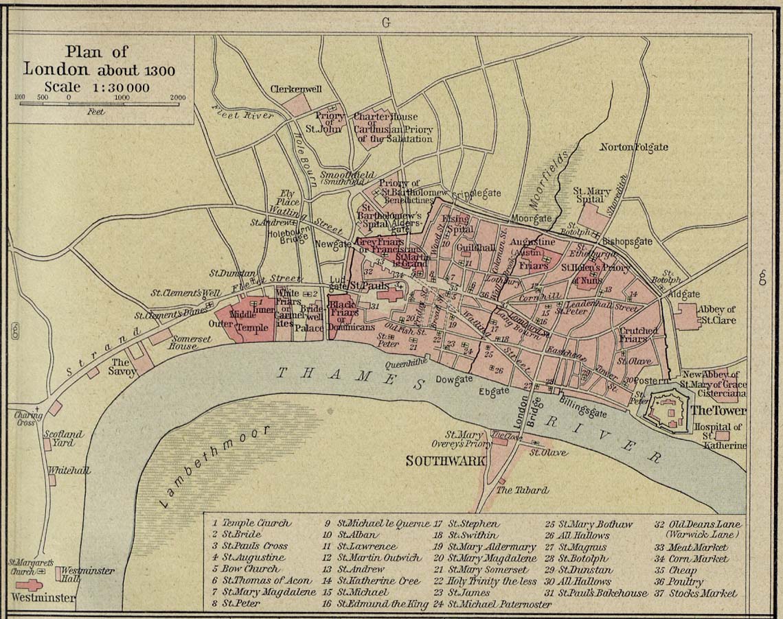
English: Source: Commons Image:London 1300 Historical Atlas William R Shepherd (died 1934).PNG
Description: A map of London in 1300 from a historical atlas by William R Shepherd. Apart from religious foundations and two or three other complexes, the city is confined within its walls, the bulk and heart of the City of London today. The City is flanked to the east and west by the royal fortress of the Tower of London and the royal palace of en:Bridewell. The route from the city to the royal centre of Westminster is not yet fully built up. There is a settlement at en:Southwark, but it is very small. The approximate location of the future Marshalsea prison (first mentioned 1370) is marked in blue. |
| Fecha | |
| Fuente | Shepherd, William R. Historical Atlas. New York, Henry Holt and Company, 1923. Direct JPG, Indirect HTML |
| Autor | Shepherd, William R. (d. 1934) |
| Permiso (Reutilización de este archivo) |
This image is in the public domain due to its age. |
.PNG)
Licencia
|
Este material está en dominio público en los demás países donde el derecho de autor se extiende por 70 años (o menos) tras la muerte del autor.
| |
| Esta obra ha sido identificada como libre de las restricciones conocidas en virtud del derecho de autor, incluyendo todos los derechos conexos. | |
Registro original de carga
- 2007-12-23 05:07 SlimVirgin 700×536×8 (709283 bytes) {{PD-old}} Source: Commons [[:Image:London 1300 Historical Atlas William R Shepherd (died 1934).PNG]] Description: A map of London in 1300 from a historical atlas by William R Shepherd. Apart from religious foundations and two or three other complexes,
Historial del archivo
Haz clic sobre una fecha y hora para ver el archivo tal como apareció en ese momento.
| Fecha y hora | Miniatura | Dimensiones | Usuario | Comentario | |
|---|---|---|---|---|---|
| actual | 02:24 7 jun 2008 | | 700 × 536 (693 kB) | File Upload Bot (Magnus Manske) | {{BotMoveToCommons|en.wikipedia}} {{Information |Description={{en|Source: Commons en::Image:London 1300 Historical Atlas William R Shepherd (died 1934).PNG Description: A map of London in 1300 from a historical atlas by William R Shepherd. Apart fr |
.PNG)
Usos del archivo
La siguiente página usa este archivo:
Uso global del archivo
Las wikis siguientes utilizan este archivo:
- Uso en it.wikipedia.org
- Uso en no.wikipedia.org