Archivo:Map of eastern Xinjiang 1939 with prehistoric sites and the courses of the Silk Roads.jpg

Ver la imagen en su resolución original(831 × 777 píxeles; tamaño de archivo: 297 kB; tipo MIME: image/jpeg)

Descripción
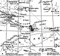
English: Map of eastern Xinjiang with prehistoric sites and the courses of the Silk Roads by Folke Bergman 1939.
Deutsch: Landkarte von Folke Bergman vom östlichen Xinjiang aus dem Jahr 1939 mit prähistorischen Fundstätten und den Routen der Seidenstraße. Bilderklärungen: . Prähistorische Fundstätte, ...... mittlere Route, — — — — vermutete südliche Route, - - - - - vermutete nördliche Route.
Fecha created: 1939 after the Sino-Swedish Expedition in China 1927-1933.
Fuente Map of eastern Xinjiang with prehistoric sites and the courses of the Silk Roads by Folke Bergman in his Book Archaeological Researches in Sinkiang. Especially the Lop-Nor Region. (Reports: Publication 7), Stockholm 1939, Page 25 Fig. 4. Copyright 2006: Sven Hedin foundation, Stockholm. [1]
Autor Folke Bergman
Permiso
(Reutilización de este archivo)

Permission cc-by-2.5 from the date 2006.08.23 by the keeper of the Sven Hedin Foundation Håkan Wahlquist, Box 27 140, SE-102 52 Stockholm, Sweden, Phone: +46-8-519 550 18, fax: +46-8-519 550 70, e-mail: hakan.wahlquist@etnografiska.se [2]

Svenska: Du måste ange upphovsmannen och/eller licensgivaren på det sätt de anger: Sven Hedin Foundation, Stockholm.
Deutsch: Namensnennung: Sie müssen den Namen des Autors/Rechtsinhabers Sven Hedin Foundation nennen: Sven Hedin Foundation, Stockholm.
w:es:Creative Commons
atribución
Este archivo está disponible bajo la licencia Creative Commons Reconocimiento 2.5 Genérica.
Eres libre:
  • de compartir – de copiar, distribuir y transmitir el trabajo
  • de remezclar – de adaptar el trabajo
Bajo las siguientes condiciones:
  • atribución – Debes otorgar el crédito correspondiente, proporcionar un enlace a la licencia e indicar si realizaste algún cambio. Puedes hacerlo de cualquier manera razonable pero no de manera que sugiera que el licenciante te respalda a ti o al uso que hagas del trabajo.

Leyendas

Añade una explicación corta acerca de lo que representa este archivo

Elementos representados en este archivo

representa a

Historial del archivo

Haz clic sobre una fecha y hora para ver el archivo tal como apareció en ese momento.

Fecha y horaMiniaturaDimensionesUsuarioComentario
actual14:00 18 sep 2006Miniatura de la versión del 14:00 18 sep 2006831 × 777 (297 kB)Michael Gäbler{{Information| |Description= Map of eastern Xinjiang with prehistoric sites and the courses of the Silk Roads by Folke Bergman 1939. de: Landkarte von Folke Bergman vom östlichen Xinjiang aus dem Jahr 1939 mit prehistorischen Fundstätten und den Routen

No hay páginas que enlacen a este archivo.

Uso global del archivo

Las wikis siguientes utilizan este archivo:

Metadatos