Archivo:Mecklenburg-Vorpommern Map Districts Border Mecklenburg Western Pomerania - Landkreise Grenzen Karte MV MeckPomm.svg

Tamaño de esta previsualización PNG del archivo SVG: 800 × 549 píxeles. Otras resoluciones: 320 × 220 píxeles · 640 × 439 píxeles · 1024 × 703 píxeles · 1280 × 879 píxeles · 2560 × 1757 píxeles · 1129 × 775 píxeles.
Ver la imagen en su resolución original ((Imagen SVG, nominalmente 1129 × 775 pixels, tamaño de archivo: 759 kB))
Resumen
| Descripción |
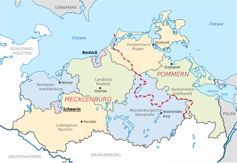
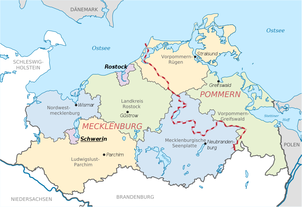
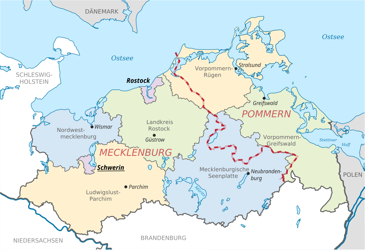
English: Locator map of counties and their seats in Mecklenburg-Vorpommern, Germany after county reorganization 2011. The red-white line indicates the former border between the state of Mecklenburg and the Prussian province of Pommerania.
Deutsch: Karte mit Lage der Landkreise und Kreisstädte in Mecklenburg-Vorpommern, Deutschland nach der Kreisgebietsreform 2011. Eingezeichnet ist auch die Grenze zwischen dem früheren Staat Mecklenburg und der preußischen Provinz Pommern. |
| Fecha | |
| Fuente | File:Mecklenburg-Vorpommern districts 2011 colored labeled Meck-Pomm-border.svg |
| Autor | TUBS |
| Otras versiones |
|


Licencia
| Este trabajo ha sido liberado al dominio público por su autor, TUBS. Esto aplica para todo el mundo. En algunos países esto puede no ser legalmente factible; si ello ocurriese: |
Historial del archivo
Haz clic sobre una fecha y hora para ver el archivo tal como apareció en ese momento.
| Fecha y hora | Miniatura | Dimensiones | Usuario | Comentario | |
|---|---|---|---|---|---|
| actual | 11:51 16 jun 2014 | | 1129 × 775 (759 kB) | Horst-schlaemma | {{Information |Description ={{en|1=Locator map of counties and their seats in Mecklenburg-Vorpommern, Germany after county reorganization 2011. The red-white line indicates the former borders of the his... |
Usos del archivo
Las siguientes páginas usan este archivo:
Uso global del archivo
Las wikis siguientes utilizan este archivo:
- Uso en af.wikipedia.org
- Uso en als.wikipedia.org
- Uso en an.wikipedia.org
- Uso en ast.wikipedia.org
- Uso en ay.wikipedia.org
- Uso en az.wikipedia.org
- Uso en ba.wikipedia.org
- Uso en be-tarask.wikipedia.org
- Uso en bg.wikipedia.org
- Uso en br.wikipedia.org
- Uso en ca.wikipedia.org
- Uso en csb.wikipedia.org
- Uso en cs.wikipedia.org
- Uso en cy.wikipedia.org
- Uso en de.wikipedia.org
- Uso en de.wikivoyage.org
- Uso en dsb.wikipedia.org
- Uso en en.wikipedia.org
- Uso en eo.wikipedia.org
- Uso en et.wikipedia.org
- Uso en eu.wikipedia.org
- Uso en fi.wikipedia.org
- Uso en frr.wikipedia.org
- Uso en fr.wikipedia.org
- Uso en fy.wikipedia.org
- Uso en ga.wikipedia.org
- Uso en gd.wikipedia.org
- Uso en gl.wikipedia.org
- Uso en gn.wikipedia.org
- Uso en gv.wikipedia.org
- Uso en he.wikipedia.org
- Uso en hr.wikipedia.org
- Uso en hsb.wikipedia.org
- Uso en hu.wikipedia.org
- Uso en hu.wiktionary.org
- Uso en ia.wikipedia.org
- Uso en id.wikipedia.org
- Uso en ie.wikipedia.org
- Uso en ilo.wikipedia.org
Ver más uso global de este archivo.