Archivo:Northridge near Dayton aerial.jpg

Tamaño de esta previsualización: 800 × 600 píxeles. Otras resoluciones: 320 × 240 píxeles · 640 × 480 píxeles · 1024 × 768 píxeles · 1280 × 960 píxeles · 2272 × 1704 píxeles.
Ver la imagen en su resolución original (2272 × 1704 píxeles; tamaño de archivo: 2,08 MB; tipo MIME: image/jpeg)
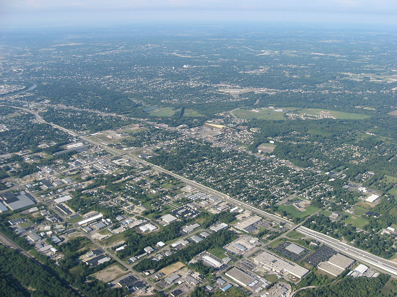
| Descripción | Aerial view of Northridge, a community on the northeast side of the city of Dayton in Montgomery County, Ohio, United States. Interstate 75 is clearly visible in the middle of the picture, with the major intersection toward the left side of the picture being the highway's interchange with Needmore Road. The Great Miami River is visible on the far left edge of the picture. Picture taken from a Diamond Eclipse light airplane at an altitude of 4,480 feet MSL and a bearing of approximately 220º. | ||
| Fecha | Tomada el 12 de agosto de 2008 | ||
| Fuente | Trabajo propio | ||
| Autor | Nyttend | ||
| Permiso (Reutilización de este archivo) |
|
Historial del archivo
Haz clic sobre una fecha y hora para ver el archivo tal como apareció en ese momento.
| Fecha y hora | Miniatura | Dimensiones | Usuario | Comentario | |
|---|---|---|---|---|---|
| actual | 00:58 19 sep 2008 | | 2272 × 1704 (2,08 MB) | Nyttend | {{Information |Description=Aerial view of {{w|Northridge, Montgomery County, Ohio|Northridge}}, a community on the northeast side of the city of {{w|Dayton, Ohio|Dayton}} in {{w|Montgomery County, Ohio|Montgomery County}}, {{w|Ohio}}, {{w|United States}}. |
Usos del archivo
La siguiente página usa este archivo:
Uso global del archivo
Las wikis siguientes utilizan este archivo:
- Uso en azb.wikipedia.org
- Uso en ca.wikipedia.org
- Uso en ceb.wikipedia.org
- Uso en en.wikipedia.org
- Uso en eu.wikipedia.org
- Uso en fa.wikipedia.org
- Uso en it.wikipedia.org
- Uso en pt.wikipedia.org
- Uso en sr.wikipedia.org
- Uso en ur.wikipedia.org
- Uso en vi.wikipedia.org
- Uso en www.wikidata.org
- Uso en zh-min-nan.wikipedia.org
- Uso en zh.wikipedia.org