Archivo:Saharat Thai Doem map.png

Tamaño de esta previsualización: 663 × 600 píxeles. Otras resoluciones: 265 × 240 píxeles · 531 × 480 píxeles · 962 × 870 píxeles.
Ver la imagen en su resolución original (962 × 870 píxeles; tamaño de archivo: 189 kB; tipo MIME: image/png)
Resumen
| Descripción |
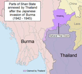
English: Parts of Shan State annexed by Thailand after the Japanese invasion of Burma. The map shows in purple the actual territories east of the Salween (Kengtung and part of Mongpan State) that were sanctioned by the Japanese authorities to become a new Thai province. Not all the territories claimed by Thailand in the Shan and Kayah states were granted by the Japanese.
Note: This is not a map of the farthest penetration of the Thai army accompanying the Japanese military in their Burma campaign. |
| Fecha | |
| Fuente | Trabajo propio |
| Autor | Xufanc |
Licencia
Yo, el titular de los derechos de autor de esta obra, la publico en los términos de la siguiente licencia:
Este archivo está disponible bajo la licencia Creative Commons Attribution-Share Alike 4.0 International.
- Eres libre:
- de compartir – de copiar, distribuir y transmitir el trabajo
- de remezclar – de adaptar el trabajo
- Bajo las siguientes condiciones:
- atribución – Debes otorgar el crédito correspondiente, proporcionar un enlace a la licencia e indicar si realizaste algún cambio. Puedes hacerlo de cualquier manera razonable pero no de manera que sugiera que el licenciante te respalda a ti o al uso que hagas del trabajo.
- compartir igual – En caso de mezclar, transformar o modificar este trabajo, deberás distribuir el trabajo resultante bajo la misma licencia o una compatible como el original.
Historial del archivo
Haz clic sobre una fecha y hora para ver el archivo tal como apareció en ese momento.
| Fecha y hora | Miniatura | Dimensiones | Usuario | Comentario | |
|---|---|---|---|---|---|
| actual | 13:01 24 may 2017 | | 962 × 870 (189 kB) | Xufanc | Undid malicious revision by User:Shoshui |
| 03:37 12 mar 2016 |  | 962 × 870 (167 kB) | Shoshui | Reverted to version as of 07:52, 6 November 2015 (UTC) | |
| 09:37 15 dic 2015 |  | 962 × 870 (193 kB) | Xufanc | Corrected title | |
| 09:08 15 dic 2015 |  | 962 × 870 (194 kB) | Xufanc | Other wording | |
| 08:59 15 dic 2015 |  | 962 × 870 (208 kB) | Xufanc | Other wording | |
| 01:57 9 nov 2015 |  | 962 × 870 (208 kB) | Xufanc | status unclear region | |
| 03:03 7 nov 2015 |  | 962 × 870 (208 kB) | Xufanc | Status unclear region | |
| 07:52 6 nov 2015 |  | 962 × 870 (167 kB) | Xufanc | Mandalay and Taunggiy was as far as the Thai troops advanced, but the map is about the parts annexed by Thailand as 'Saharat Thai Doem'. It is not a map of the farthest penetration of the Phayap Army | |
| 06:25 14 sep 2015 |  | 962 × 870 (166 kB) | Shoshui | The area include Mandalay and Taunggyi. | |
| 06:16 14 sep 2015 |  | 962 × 870 (166 kB) | Shoshui | The area include Mandalay and Taunggyi. |
Usos del archivo
La siguiente página usa este archivo:
Uso global del archivo
Las wikis siguientes utilizan este archivo:
- Uso en en.wikipedia.org
- Uso en fr.wikipedia.org
- Uso en it.wikipedia.org
- Uso en my.wikipedia.org
- Uso en ru.wikipedia.org
- Uso en th.wikipedia.org
- Uso en uk.wikipedia.org
- Uso en vi.wikipedia.org
- Uso en zh.wikipedia.org