Archivo:Site of the Battle of Beecher Island as it appeared in 1917.jpg
No se dispone de una resolución más alta.
Site_of_the_Battle_of_Beecher_Island_as_it_appeared_in_1917.jpg (640 × 342 píxeles; tamaño de archivo: 40 kB; tipo MIME: image/jpeg)
|
Esto es una imagen de un lugar o edificio incluido en el Registro Nacional de Lugares Históricos de los Estados Unidos. Su número de referencia es 76000569. |
Resumen
| Descripción |
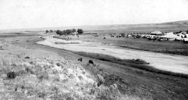
English: The site of the 1868 Battle of Beecher Island — as it appeared in 1917.
|
| Fuente | Earl Alonzo Brininstool |
| Autor | Earl Alonzo Brininstool |
| Ubicación del objeto | | Ubicación de esta y otras imágenes en: OpenStreetMap |
|---|
Licencia
Este archivo está en el dominio público en los Estados Unidos. Esto se aplica a los trabajos de Estados Unidos donde los derechos de autor han expirado, a menudo porque su primera publicación ocurrió antes del 1 de enero de 1929. Véase esta página para explicación adicional.
|
 | |
 |
Esta imagen puede estar protegida fuera de los Estados Unidos —especialmente en Canadá, China (excepto Hong-Kong, Macao, o el área de Taiwán), Alemania o Suiza—. El creador y el año de publicación son información esencial y deben ser proporcionados. Véase Wikipedia:Derechos de autor para más detalles.
|
Registro original de carga
Aquí se muestra la página de descripción original. Los siguientes nombres de usuario se refieren a en.wikipedia.
- 2006-06-30 21:18 Lordkinbote 640×342× (40670 bytes) The site of the Battle of Beecher Island as it appeared in 1917. The south channel of the Arickaree has been closed, owing to the sifting sands of the stream. Shown are tents, buildings, horses, and cattle at an annual scout reunion to commemorate the
Historial del archivo
Haz clic sobre una fecha y hora para ver el archivo tal como apareció en ese momento.
| Fecha y hora | Miniatura | Dimensiones | Usuario | Comentario | |
|---|---|---|---|---|---|
| actual | 03:01 5 oct 2011 | | 640 × 342 (40 kB) | File Upload Bot (Magnus Manske) | {{BotMoveToCommons|en.wikipedia|year={{subst:CURRENTYEAR}}|month={{subst:CURRENTMONTHNAME}}|day={{subst:CURRENTDAY}}}} {{Information |Description={{en|The site of the Battle of Beecher Island as it appeared in 1917. The south channel of the Arickaree has |
Usos del archivo
La siguiente página usa este archivo:
Uso global del archivo
Las wikis siguientes utilizan este archivo:
- Uso en de.wikipedia.org
- Uso en en.wikipedia.org
- Uso en ur.wikipedia.org
- Uso en www.wikidata.org