Archivo:Txu-oclc-6654394-nk-52-4th-ed.jpg

Tamaño de esta previsualización: 490 × 599 píxeles. Otras resoluciones: 196 × 240 píxeles · 392 × 480 píxeles · 628 × 768 píxeles · 837 × 1024 píxeles · 1674 × 2048 píxeles · 4087 × 5000 píxeles.
Ver la imagen en su resolución original (4087 × 5000 píxeles; tamaño de archivo: 6,55 MB; tipo MIME: image/jpeg)
Resumen
| Descripción |
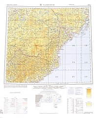
English: Map from the International Map of the World 1:1,000,000 (from map: "DELINEATION OF INTERNATIONAL BOUNDARIES MUST NOT BE CONSIDERED AUTHORITATIVE") |
| Fecha |
Compiled: 1967 Printed: October 1967 Scanned: 2007-04-03 06:33:57 |
| Fuente | Courtesy of the University of Texas Libraries, The University of Texas at Austin. ([1]) |
| Autor | Army Map Serivce (LU), Corps of Engineers, 1967 |
![[1]](http://legacy.lib.utexas.edu/maps/imw/txu-oclc-6654394-nk-52-4th-ed.jpg)
Licencia
This image or file is a work of a U.S. Army Corps of Engineers soldier or employee, taken or made as part of that person's official duties. As a work of the U.S. federal government, the image is in the public domain.
|
Historial del archivo
Haz clic sobre una fecha y hora para ver el archivo tal como apareció en ese momento.
| Fecha y hora | Miniatura | Dimensiones | Usuario | Comentario | |
|---|---|---|---|---|---|
| actual | 06:07 7 dic 2019 | | 4087 × 5000 (6,55 MB) | Geographyinitiative | User created page with UploadWizard |
Usos del archivo
La siguiente página usa este archivo:
Uso global del archivo
Las wikis siguientes utilizan este archivo:
- Uso en ar.wikipedia.org
- Uso en en.wikipedia.org
- Uso en en.wiktionary.org
- Uso en he.wikipedia.org
- Uso en it.wikipedia.org
- Uso en pa.wikipedia.org
- Uso en pnb.wikipedia.org
- Uso en th.wikipedia.org
- Uso en uz.wikipedia.org
- Uso en vi.wikipedia.org