Archivo:Voyage of Blonde 1824 sm.png

Ver la imagen en su resolución original(790 × 800 píxeles; tamaño de archivo: 164 kB; tipo MIME: image/png)

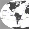
Descripción Map of the Voyage of the Blonde, showing the main places visited. Note that the lines between these places are purely schematic and do not represent the actual route. The journey out to Hawaii is shown in blue, the return in green.
Fecha (UTC)
Fuente
Autor


Esta es una imagen retocada, lo que significa que ha sido alterada digitalmente de su versión original. Modificaciones: Added places and lines between them; darkened the land. La original se puede ver aquí: WorldMap.svg. Las modificaciones las hizo Peter coxhead.


Public domain
Esta imagen se encuentra en el dominio público ya que su contenido proviene de CIA World Factbook, un trabajo de la Agencia Central de Inteligencia de los Estados Unidos de América.

Bahasa Indonesia  čeština  Deutsch  eesti  English  español  Esperanto  français  galego  hrvatski  italiano  Nederlands  norsk nynorsk  polski  português  sicilianu  slovenščina  suomi  Türkçe  Zazaki  беларуская (тарашкевіца)  македонски  русский  српски / srpski  українська  ქართული  বাংলা  தமிழ்  മലയാളം  한국어  日本語  中文  中文(简体)  中文(繁體)  العربية  +/−


Registro original de carga

This image is a derivative work of the following images:

  • File:WorldMap.svg licensed with PD-USGov-CIA-WF
    • 2009-01-01T14:51:09Z CodeOne 2760x1398 (520387 Bytes) == Summary == This is a recreated version of [[:Image:LocationWorld.png]] using vector graphics. Original description: Large plain-grey map of world created by adapting [[:Image:LocationSouthAmerica.png]]. Previous image upl

Uploaded with derivativeFX

Leyendas

Añade una explicación corta acerca de lo que representa este archivo

Elementos representados en este archivo

representa a

Historial del archivo

Haz clic sobre una fecha y hora para ver el archivo tal como apareció en ese momento.

Fecha y horaMiniaturaDimensionesUsuarioComentario
actual08:58 6 dic 2009Miniatura de la versión del 08:58 6 dic 2009790 × 800 (164 kB)Peter coxheadMade lines representing the voyage thicker; added arrows
16:25 5 dic 2009Miniatura de la versión del 16:25 5 dic 2009790 × 800 (168 kB)Peter coxhead{{Information |Description=Map of the Voyage of the ''Blonde'', showing the main places visited. Note that the lines between these places are purely schematic and do not represent the actual route. |Source=*File:WorldMap.svg

Las siguientes páginas usan este archivo:

Uso global del archivo

Las wikis siguientes utilizan este archivo: