Archivo:Wfm jura landsat.jpg

Tamaño de esta previsualización: 800 × 593 píxeles. Otras resoluciones: 320 × 237 píxeles · 640 × 474 píxeles · 1024 × 758 píxeles · 1280 × 948 píxeles.
Ver la imagen en su resolución original (1280 × 948 píxeles; tamaño de archivo: 328 kB; tipo MIME: image/jpeg)
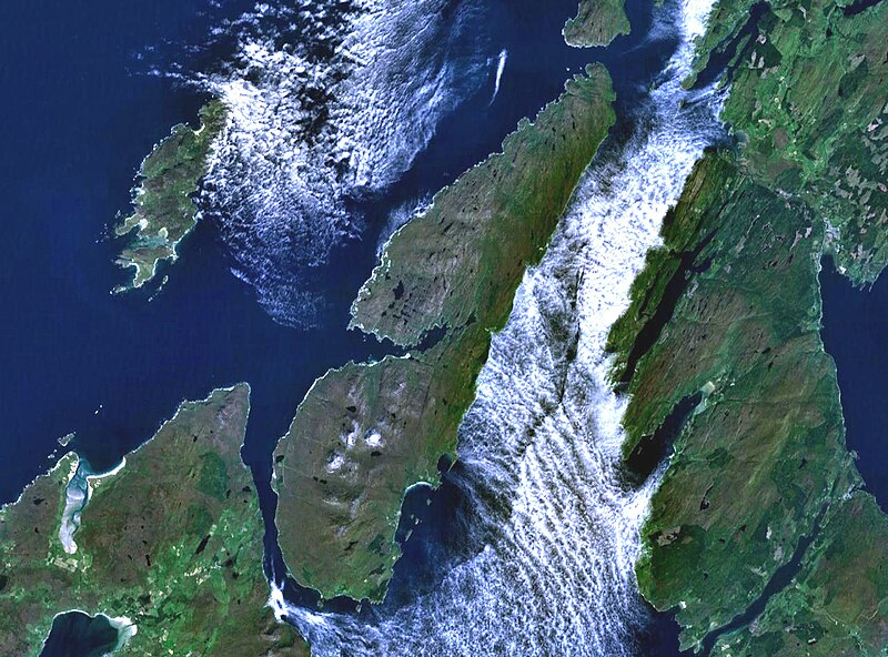
The island of Jura off the west coast of Scotland. The large island to the southwest is Islay, and north of it is Colonsay. To the east is the Kintyre peninsula. The small round island just to the north is Scarba.
This is Landsat7 imagery, collected using NASA World Wind.
| Esta imagen se encuentra en el dominio público porque es una captura de pantalla del software de globo terráqueo de la NASA, World Wind, que utiliza una capa de dominio público, como Blue Marble, MODIS, Landsat, SRTM, USGS o GLOBE.
|
 |
Historial del archivo
Haz clic sobre una fecha y hora para ver el archivo tal como apareció en ese momento.
| Fecha y hora | Miniatura | Dimensiones | Usuario | Comentario | |
|---|---|---|---|---|---|
| actual | 19:48 4 ago 2005 | | 1280 × 948 (328 kB) | Finlay McWalter | The island of Jura off the west coast of Scotland. This is Landsat7 imagery, collected using NASA World Wind. {{PD-USGov-NASA}} category:islands category:scotland category:satellite photos |
Usos del archivo
Las siguientes páginas usan este archivo:
Uso global del archivo
Las wikis siguientes utilizan este archivo:
- Uso en br.wikipedia.org
- Uso en cs.wikipedia.org
- Uso en de.wikipedia.org
- Uso en el.wikipedia.org
- Uso en en.wikipedia.org
- Scarba
- Craighouse
- Feolin
- Beinn an Òir
- Beinn Shiantaidh
- Beinn a' Chaolais
- Paps of Jura
- Ardfernal
- Ardmenish
- Jura, Scotland
- Barnhill, Jura
- List of listed buildings in Jura, Argyll and Bute
- Ardlussa Fishing Loch
- Ardfin
- Small Isles, Argyll
- Template:Jura
- Am Fraoch Eilean
- Brosdale Island
- Lagg, Jura
- Tarbert, Jura
- Keils
- Inverlussa
- Kinuachdrachd
- Ardlussa
- Knockrome
- Uso en en.wiktionary.org
- Uso en fr.wikipedia.org
- Uso en gl.wikipedia.org
- Uso en it.wikipedia.org
- Uso en ja.wikipedia.org
- Uso en la.wikipedia.org
- Uso en nds.wikipedia.org
- Uso en nl.wikipedia.org
- Uso en nn.wikipedia.org
- Uso en no.wikipedia.org
- Uso en pl.wikipedia.org
- Uso en pt.wikipedia.org
- Uso en sr.wikipedia.org
- Uso en sv.wikipedia.org
- Uso en uk.wikipedia.org
- Uso en www.wikidata.org