Archivo:Map of the route of Edward III's chevauchée of 1346.svg

Tamaño de esta previsualización PNG del archivo SVG: 643 × 600 píxeles. Otras resoluciones: 257 × 240 píxeles · 515 × 480 píxeles · 823 × 768 píxeles · 1098 × 1024 píxeles · 2195 × 2048 píxeles · 1059 × 988 píxeles.
Ver la imagen en su resolución original ((Imagen SVG, nominalmente 1059 × 988 pixels, tamaño de archivo: 450 kB))
Resumen
| Descripción |
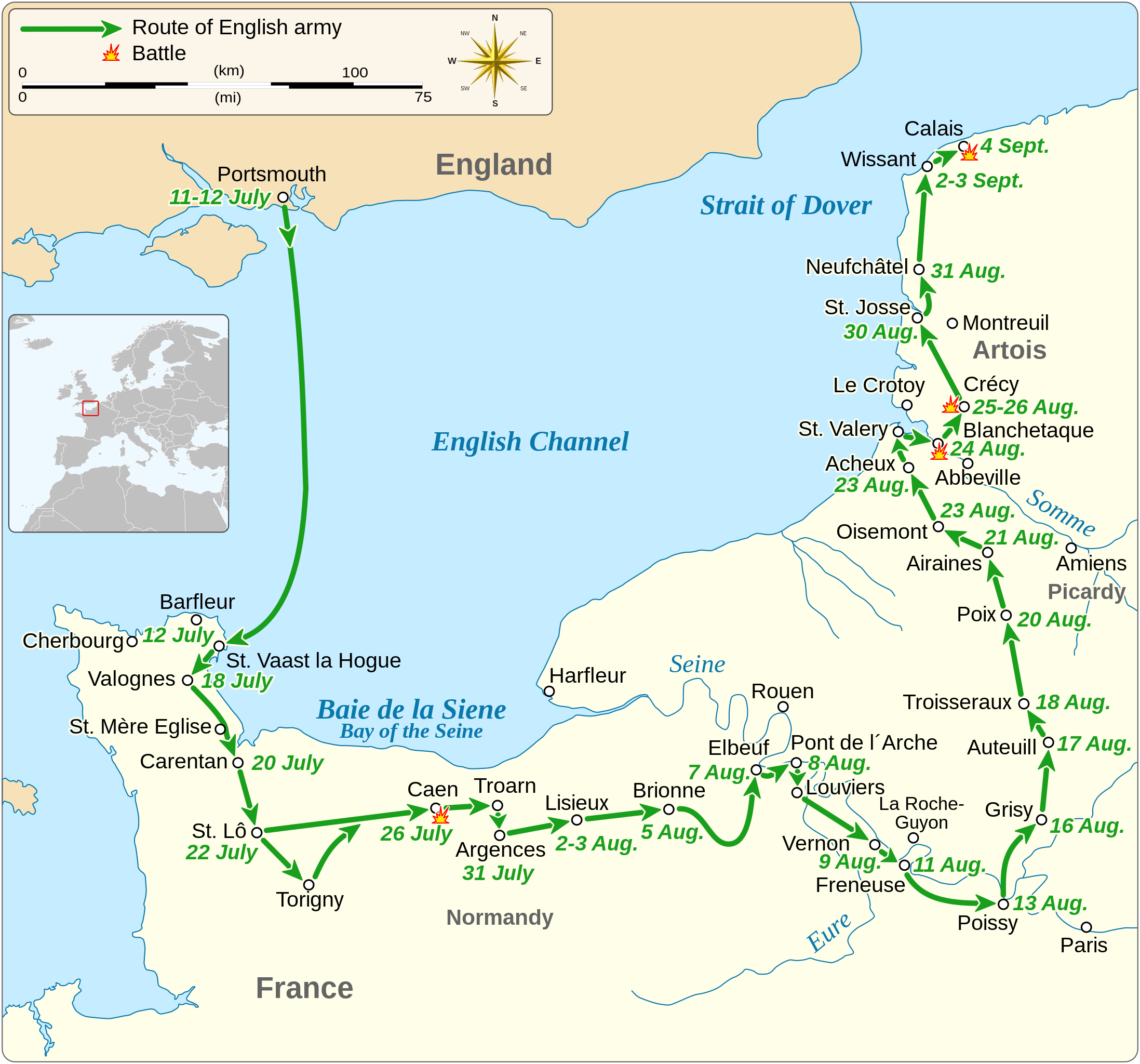
English: Map of the route of Edward III's chevauchée of 1346, part of the Hundred Years' War. This map shows the English army movements during the campaign and the most important battles.
|
||||||||||||||||||||||||||||||||||||||||||||||||
| Fecha | |||||||||||||||||||||||||||||||||||||||||||||||||
| Fuente |
Trabajo propio Derived from; Information from:
|
||||||||||||||||||||||||||||||||||||||||||||||||
| Autor | Goran tek-en | ||||||||||||||||||||||||||||||||||||||||||||||||
| Permiso (Reutilización de este archivo) |
Este archivo está disponible bajo la licencia Creative Commons Attribution-Share Alike 4.0 International. Atribución: Goran tek-en
|
||||||||||||||||||||||||||||||||||||||||||||||||
| SVG desarrollo | El código fuente de esta imagen SVG es válido. Este gráfico vectorial fue creado con Inkscape. |
||||||||||||||||||||||||||||||||||||||||||||||||


| Ubicación del objeto | | Ubicación de esta y otras imágenes en: OpenStreetMap |
|---|


Historial del archivo
Haz clic sobre una fecha y hora para ver el archivo tal como apareció en ese momento.
| Fecha y hora | Miniatura | Dimensiones | Usuario | Comentario | |
|---|---|---|---|---|---|
| actual | 00:14 3 feb 2022 | | 1059 × 988 (450 kB) | Iso10970 | Reverted to version as of 13:17, 9 November 2021 (UTC) |
| 00:13 3 feb 2022 |  | 1059 × 988 (614 kB) | Iso10970 | File uploaded using svgtranslate tool (https://svgtranslate.toolforge.org/). Added translation for ja. | |
| 13:17 9 nov 2021 |  | 1059 × 988 (450 kB) | Goran tek-en | Changed view box, font size, added location map | |
| 13:06 14 abr 2019 |  | 1059 × 988 (191 kB) | Goran tek-en | Spelling | |
| 17:53 10 mar 2019 |  | 1059 × 988 (115 kB) | JoKalliauer | phab:T36947 bad character aligment on same sizes | |
| 14:08 6 mar 2019 |  | 1059 × 988 (191 kB) | Goran tek-en | {{Information |description ={{en|1=Map of the route of Edward III's chevauchée of 1346, part of the Hundred Years' War. This map shows the English army movements during the campaign and the most important battles.}} |date =20190306 |source ={{Own}}<br> Derived from; * [https://www.openstreetmap.org/#map=8/49.919/1.371 OSM] Information from: * [https://www.themaparchive.com/the-crecy-campaign-12-july-to-4-september-1346.html themaparchive.com] * {{U|Newm30}} |author... |
Usos del archivo
La siguiente página usa este archivo:
Uso global del archivo
Las wikis siguientes utilizan este archivo:
- Uso en cs.wikipedia.org
- Uso en en.wikipedia.org
- Uso en fi.wikipedia.org
- Uso en fr.wikipedia.org
- Uso en hu.wikipedia.org
- Uso en ja.wikipedia.org
- Uso en nl.wikipedia.org
- Uso en pt.wikipedia.org
- Uso en ru.wikipedia.org
- Uso en sh.wikipedia.org
- Uso en tr.wikipedia.org
- Uso en zh.wikipedia.org